These maps are interpolated groundwater depths, in metres below ground surface. Between December 2015 and now (September 2017) monthly measurements of depth to the static water table were made at approximately 150 locations across Bangalore. These measurements were largely made at abandoned/unused borewells.
Below, individual interpolated groundwater maps of the static water table can be viewed/downloaded. An animation is also provided. The locations of each well that was monitored are indicated by the circles.
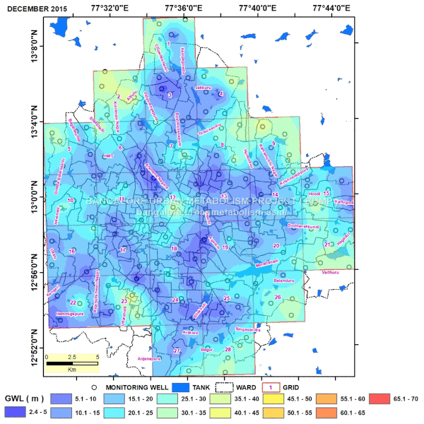
The measured depths were interpolated. Like all interpolations, there are uncertainties with interpolated data. This is especially true of Bangalore’s hard-rock aquifers, where there is large spatial variation in aquifer hydraulic properties from one location to another, even close by. Hence these maps should be treated as indicative of neighborhood-scale to ward-scale static water tables, and should not be interpreted as providing exact water table depths at point (example, household) scale. At the household scale the following factors can contribute to differences in observed groundwater depths from the interpolated maps: geologic variability, differing well depths and screening depths, and effects of pumping.
To download the individual maps and full size animation, please subscribe to our newsletter.
By downloading these files I acknowledge that (i) this data will be used only for non-commercial, research and education purposes, (ii) the individual contributors or developers of this data and website are not responsible for any (mis)use or (mis)interpretations of the data, (iii) that I will in no way change/manipulate the downloaded data, and (iv) that I will appropriately cite this data and its authors whenever in any presentation/publication where I use it.
Cite as follows: Sekhar, M., Tomer, Sat Kumar, Thiyaku, S., Giriraj, P., Murthy, Sanjeeva and Mehta, Vishal K., (2017), Groundwater Level Dynamics in Bengaluru City, India, Sustainability, 10, issue 1, p. 1-22. URL: Groundwater Level Dynamics in Bengaluru City, India